BMO Boating Adventure
Saturday morning I was finally feeling up to doing something I'd been planning on for weeks - joining some of my co-workers on one of their boats to go on a BMO Boating Adventure. I wasn't over my sickness yet but I would've been well enough to work and have fun - and I felt the fresh sea air would be good for me. And I was right.
LEG 1 - RIVER ROCK CASINO, RICHMOND TO SNUG COVE, BOWEN ISLAND
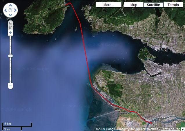
The boat was moored at the River Rock Casino in Richmond, not far from where my daily commute to work takes me. Just being near a casino reminded me of how I want to get back to Vegas some time soon.

River Rock Casino Resort Marina
The casino is located on a very busy part of the Fraser River in between about five bridges full of freeways and trains, so there was plenty to see there. Not long after, though, we were sailing up the North Arm of the Fraser River passing by a number of luxury houses on the north, Vancouver International Airport to the south, and a bunch of logbooms down the middle.

Log booms and tugboats on the North Arm of the mighty Fraser

You can see the river just north of the airport here.
The further northwest we go, the closer we get to the open water of the Strait of Georgia, and the less we see of anything else...but more log booms.

More log booms! Beyond the jetty in this pic is the Strait of Georiga, and beyond that, Vancouver Island.
Leaving the Fraser we cruise past the University of British Columbia, perched a hundred metres high on a bluff overlooking the ocean, and Wreck Beach, Vancouver's most famous nude beach, on the sandy shores below.

Ariel view of Wreck Beach, Vancouver, BC

Wreck Beach and the log booms in the foreground, UBC in the centre, Burrard Inlet and the rest of Vancouver in the background.
After we passed Wreck Beach we gunned it for about 20 minutes across rough open waters towards Snug Cove, Bowen Island. I hadn't been there in nearly a year, the last (and only) time being when my friend Shar got married last August. It was good times. So was this - but unlike last time when we arrived on the ferry, this time we arrived in style!

Bowen Island, looking southwest from the mainland.

Snug Cove, Bowen Island, were we docked and had lunch for a few hours.

The small, quaint boardwalk at Snug Cove.
LEG 2 - BOWEN ISLAND TO FALSE CREEK
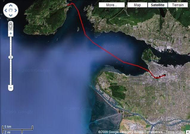
After lunch we got back on the boat and sailed back towards Vancouver - but not before getting some good looks at the lovely scenery north of us that the mountains and Howe Sound provided.

The land in the forefront here is actually Horseshoe Bay, on the mainland, 15 minutes from Snug Cove. To the top/north of the picture you will see the way to get to Whistler, BC.
Coming around Lighthouse Park in West Vancouver, we then got our glimpse of the downtown Vancouver skyline - and it was full steam ahead.

The West End of Vancouver, with a hint of Stanley Park on the far left.
Of course to get there we had to navigate between all the giant freighters that are always moored far out in English Bay, waiting to be allowed into the port.

Freighters in English Bay...at sunset. We were there at about 3pm.
We soon made it to False Creek and just looked at the many Vancouver attractions there before turning around.

Vancouver's famous Inukshuk, welcoming visitors to the city. It's not of local origin but since 1986 it has grown to become one of the famous symbols of the city - and logo of the 2010 Winter Olympics.

Sailing under the Burrard Street Bridge (with the Granville Street Bridge in the background.
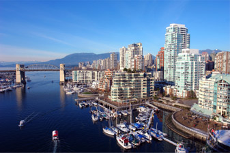
The picturesque but very bustling False Creek.

False Creek, with the Granville Island tourist trap in the foreground.

Under the Granville Street Bridge, we saw one of multiple rainbow-coloured foot-passenger aquabus ferries; these things are so out of control. Nearly hit us what, like five times? Or at least it felt that way.
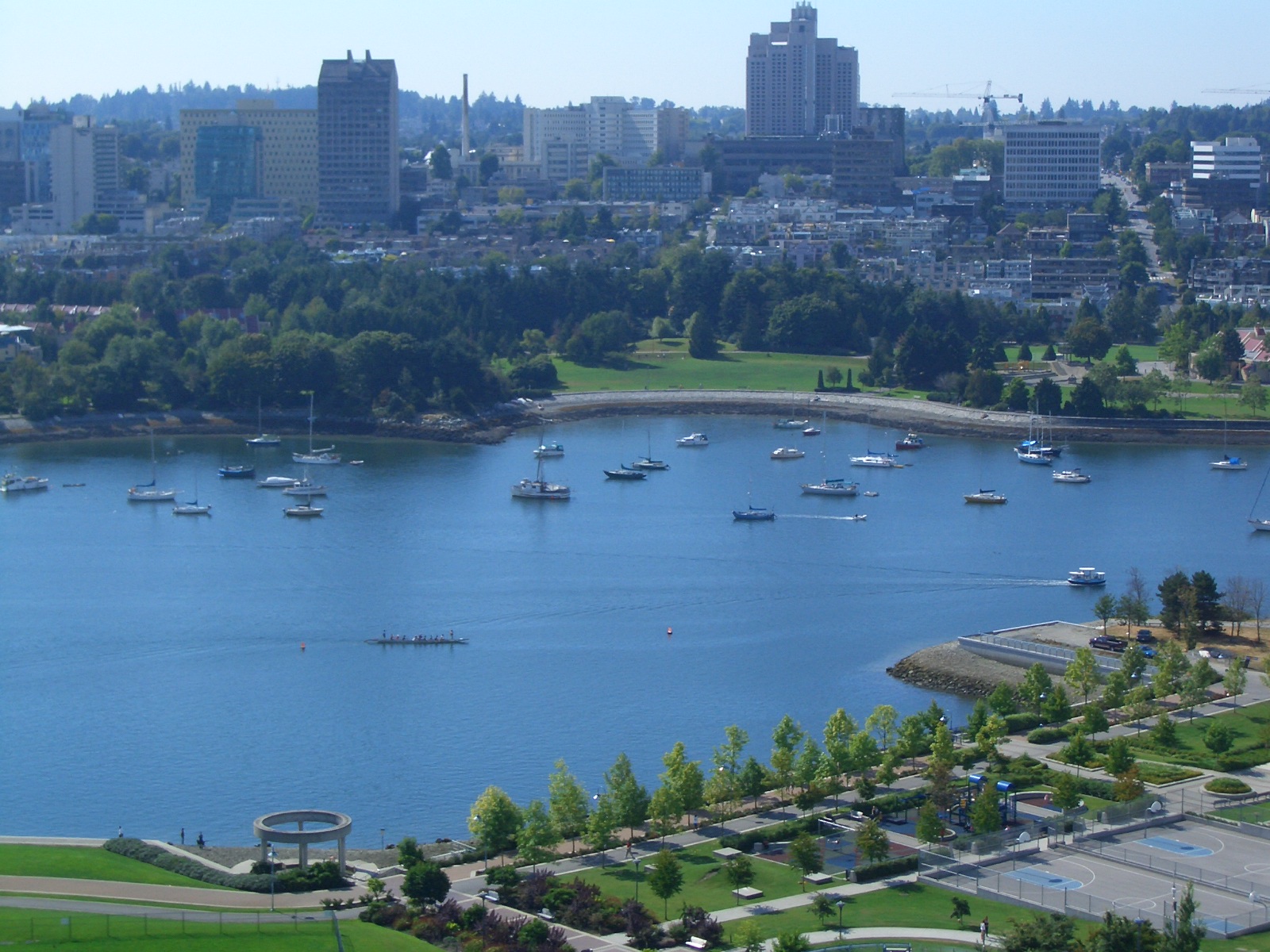
Central False Creek, facing south. Lots of boat squatters set up shop here because the marinas are too busy and pricy. Near side of the water: The old Expo 86 lands. Large building at the top centre of the picture: Vancouver General Hospital.

Crossing under the third of three bridges to span False Creek, the Cambie Street Bridge. To the right, a portion of BC Place Stadium.
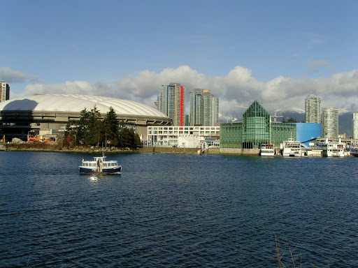
Looking north from eastern False Creek. Left: BC Place. Right: Edgewater Casino.

Science World, at the eastern end of False Creek, where we turned around and went home.

Vancouver's controversial Olympic Village, under construction, in the southeast corner of the False Creek lands.
LEG 3 - FALSE CREEK BACK HOME
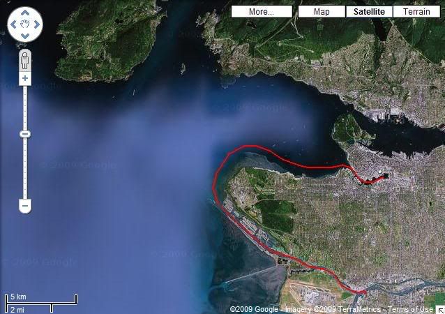
We were all pretty tired by this point so after slowly leaving False Creek the way we came, we gunned it around the big bend of UBC, back past the nude beach, and up the river back to the casino.
It was a great day, even though the weather got progressively gloomier as the hours passed. Funny thing - something I don't recall from other boat excursions - was that while I had good sea legs on the boat, as soon as I was on land I couldn't balance as well. Even when I was sleeping that night, it felt like my bed was rocking back and forth, as on the sea. It was odd - but kind of relaxing.
Now I want a boat. Some day, Tim. Some day...
LEG 1 - RIVER ROCK CASINO, RICHMOND TO SNUG COVE, BOWEN ISLAND

The boat was moored at the River Rock Casino in Richmond, not far from where my daily commute to work takes me. Just being near a casino reminded me of how I want to get back to Vegas some time soon.

River Rock Casino Resort Marina
The casino is located on a very busy part of the Fraser River in between about five bridges full of freeways and trains, so there was plenty to see there. Not long after, though, we were sailing up the North Arm of the Fraser River passing by a number of luxury houses on the north, Vancouver International Airport to the south, and a bunch of logbooms down the middle.

Log booms and tugboats on the North Arm of the mighty Fraser

You can see the river just north of the airport here.
The further northwest we go, the closer we get to the open water of the Strait of Georgia, and the less we see of anything else...but more log booms.

More log booms! Beyond the jetty in this pic is the Strait of Georiga, and beyond that, Vancouver Island.
Leaving the Fraser we cruise past the University of British Columbia, perched a hundred metres high on a bluff overlooking the ocean, and Wreck Beach, Vancouver's most famous nude beach, on the sandy shores below.

Ariel view of Wreck Beach, Vancouver, BC
Wreck Beach and the log booms in the foreground, UBC in the centre, Burrard Inlet and the rest of Vancouver in the background.
After we passed Wreck Beach we gunned it for about 20 minutes across rough open waters towards Snug Cove, Bowen Island. I hadn't been there in nearly a year, the last (and only) time being when my friend Shar got married last August. It was good times. So was this - but unlike last time when we arrived on the ferry, this time we arrived in style!

Bowen Island, looking southwest from the mainland.

Snug Cove, Bowen Island, were we docked and had lunch for a few hours.

The small, quaint boardwalk at Snug Cove.
LEG 2 - BOWEN ISLAND TO FALSE CREEK

After lunch we got back on the boat and sailed back towards Vancouver - but not before getting some good looks at the lovely scenery north of us that the mountains and Howe Sound provided.
The land in the forefront here is actually Horseshoe Bay, on the mainland, 15 minutes from Snug Cove. To the top/north of the picture you will see the way to get to Whistler, BC.
Coming around Lighthouse Park in West Vancouver, we then got our glimpse of the downtown Vancouver skyline - and it was full steam ahead.

The West End of Vancouver, with a hint of Stanley Park on the far left.
Of course to get there we had to navigate between all the giant freighters that are always moored far out in English Bay, waiting to be allowed into the port.

Freighters in English Bay...at sunset. We were there at about 3pm.
We soon made it to False Creek and just looked at the many Vancouver attractions there before turning around.

Vancouver's famous Inukshuk, welcoming visitors to the city. It's not of local origin but since 1986 it has grown to become one of the famous symbols of the city - and logo of the 2010 Winter Olympics.

Sailing under the Burrard Street Bridge (with the Granville Street Bridge in the background.

The picturesque but very bustling False Creek.

False Creek, with the Granville Island tourist trap in the foreground.

Under the Granville Street Bridge, we saw one of multiple rainbow-coloured foot-passenger aquabus ferries; these things are so out of control. Nearly hit us what, like five times? Or at least it felt that way.

Central False Creek, facing south. Lots of boat squatters set up shop here because the marinas are too busy and pricy. Near side of the water: The old Expo 86 lands. Large building at the top centre of the picture: Vancouver General Hospital.

Crossing under the third of three bridges to span False Creek, the Cambie Street Bridge. To the right, a portion of BC Place Stadium.
Looking north from eastern False Creek. Left: BC Place. Right: Edgewater Casino.

Science World, at the eastern end of False Creek, where we turned around and went home.

Vancouver's controversial Olympic Village, under construction, in the southeast corner of the False Creek lands.
LEG 3 - FALSE CREEK BACK HOME

We were all pretty tired by this point so after slowly leaving False Creek the way we came, we gunned it around the big bend of UBC, back past the nude beach, and up the river back to the casino.
It was a great day, even though the weather got progressively gloomier as the hours passed. Funny thing - something I don't recall from other boat excursions - was that while I had good sea legs on the boat, as soon as I was on land I couldn't balance as well. Even when I was sleeping that night, it felt like my bed was rocking back and forth, as on the sea. It was odd - but kind of relaxing.
Now I want a boat. Some day, Tim. Some day...