Dad's Home
After reading on the Butte County Sheriff's Department's web site that the area where my father lives had been downgraded from an Evacuation Order ("go now") to a Warning ("get ready to go"), meaning people could come back to their homes, I called Dad, who had indeed gotten home the following evening after spending a week in a hotel in Roseville with his wife. (They have a small dog, and needed to go that far to find a place that would let them bring their dog.) As he's a retired Forest Service ranger, I was not surprised that he bugged out before a reverse-911 evacuation order came. He could see what was going on, and while he has an extensive water system on his property, it would not have been enough had the fire reached his home, which thankfully it did not, although it was a near thing.
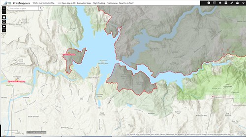
Using the FireMappers web application, I zoomed in to the Oroville/Lake Oroville area. (If you don't know where these places are, Google Is Your Friend.) The dark areas are the southern portion of the North Complex West Zone (formerly the Bear) Fire. The names kept changing because the Bear and Claremont Fires merged with other fires to become the North Complex, and the western portion of it is being managed by CalFire (state) and the rest by the US Forest Service (federal).
Most of the shaded area is now burned out and is not actively on fire. This is why they started letting people go home. If you go look at the FireMappers application, you can scroll around and find areas that have hot spots, indicating active fire areas, such as the area north of Woodleaf and Clipper Mills.
Lake Oroville is in the middle of this map, and you can see that the fire jumped the south fork of the Feather River into an area labeled as South Bidwell Hill and Stringtown Mountain. Between those two peaks is a stream labeled Woodman Ravine, and it points almost straight south at my father's property.
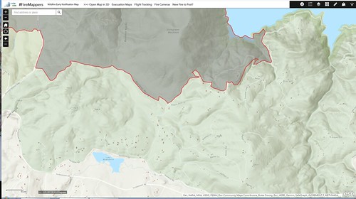
Without doxing my father, here's a closer look at the community of Hurleton, located around Lake Wyandotte off the Forbestown Road. My father's five acres is on one of the small roads feeding off Hurleton Road. Measuring with Google Maps, I determined that the southern edge of the burned area was around 1000 m (0.6 mi) north of my father's property. Had the winds kept blowing, the fire could have escaped over the ridge and up Woodman Ravine, and all of the people in Hurleton would have lost their homes.
I talked with Dad for a while. We're not close, and I haven't seen him in years, but I'm glad that he's safe. They're having to clean up the house, though, albeit not from fire damage. They had stocked up extensively to avoid having to expose themselves to idiots while shopping, and when the power went out for several days, all of the perishable foods perished. While that's a pity - Dad said they had a 50-gallon drum full of spoiled food awaiting disposal - it's relatively small potatoes next to saving their property and the house that he built when he retired from the USFS.
Using the FireMappers web application, I zoomed in to the Oroville/Lake Oroville area. (If you don't know where these places are, Google Is Your Friend.) The dark areas are the southern portion of the North Complex West Zone (formerly the Bear) Fire. The names kept changing because the Bear and Claremont Fires merged with other fires to become the North Complex, and the western portion of it is being managed by CalFire (state) and the rest by the US Forest Service (federal).
Most of the shaded area is now burned out and is not actively on fire. This is why they started letting people go home. If you go look at the FireMappers application, you can scroll around and find areas that have hot spots, indicating active fire areas, such as the area north of Woodleaf and Clipper Mills.
Lake Oroville is in the middle of this map, and you can see that the fire jumped the south fork of the Feather River into an area labeled as South Bidwell Hill and Stringtown Mountain. Between those two peaks is a stream labeled Woodman Ravine, and it points almost straight south at my father's property.
Without doxing my father, here's a closer look at the community of Hurleton, located around Lake Wyandotte off the Forbestown Road. My father's five acres is on one of the small roads feeding off Hurleton Road. Measuring with Google Maps, I determined that the southern edge of the burned area was around 1000 m (0.6 mi) north of my father's property. Had the winds kept blowing, the fire could have escaped over the ridge and up Woodman Ravine, and all of the people in Hurleton would have lost their homes.
I talked with Dad for a while. We're not close, and I haven't seen him in years, but I'm glad that he's safe. They're having to clean up the house, though, albeit not from fire damage. They had stocked up extensively to avoid having to expose themselves to idiots while shopping, and when the power went out for several days, all of the perishable foods perished. While that's a pity - Dad said they had a 50-gallon drum full of spoiled food awaiting disposal - it's relatively small potatoes next to saving their property and the house that he built when he retired from the USFS.