We're dreaming of an ash-and-soot-covered Christmas....
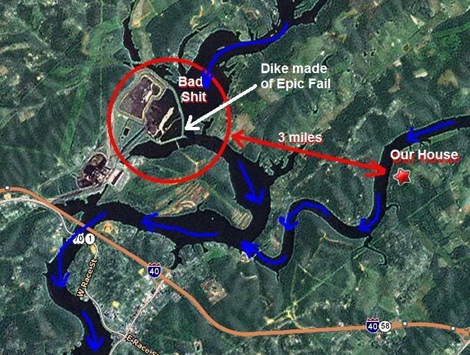
Okay, so now the dike breach has made all national news outlets and caused my mother to call and ask if we were okay (the show she was watching made it sound like it had happened just now and was explosive). So for the idly curious, I have a map.
That's the power plant there on the left, and that's our house on the right. The blue arrows show the direction of waterflow in the rivers around. The water treatment plant for Kingston is off the bottom of the map, downriver another two miles. Its water is NOT contaminated. All water levels are way down the past few days because they've dammed everything up upriver to stop the washing of sludge downstream. As you can see, the tributary we live on is UPSTREAM of the disaster area, so that bodes well for water contamination. City says there is none, but Trotfox and I are getting our own test kit in the morning. We have filters on all our showers and on the kitchen sink, and only drink Brita water, which catches some contaminants, though not heavy metals. The "water boil" order has been lifted, but that only means that CITY water is tested and safe. We're on a well.

The part that worries me is when all that shite starts to dry out and blow eastward in the wind.
This house holds a toddler and a singer. No airbourne carcinogens for us, please.
Aw, hell. I am so SICK of moving.
>:-/
That's the power plant there on the left, and that's our house on the right. The blue arrows show the direction of waterflow in the rivers around. The water treatment plant for Kingston is off the bottom of the map, downriver another two miles. Its water is NOT contaminated. All water levels are way down the past few days because they've dammed everything up upriver to stop the washing of sludge downstream. As you can see, the tributary we live on is UPSTREAM of the disaster area, so that bodes well for water contamination. City says there is none, but Trotfox and I are getting our own test kit in the morning. We have filters on all our showers and on the kitchen sink, and only drink Brita water, which catches some contaminants, though not heavy metals. The "water boil" order has been lifted, but that only means that CITY water is tested and safe. We're on a well.

The part that worries me is when all that shite starts to dry out and blow eastward in the wind.
This house holds a toddler and a singer. No airbourne carcinogens for us, please.
Aw, hell. I am so SICK of moving.
>:-/