Interactive Map
There is something about interactive maps.
Or maybe it's the colors ... and the statistics ... or the fact it's the country of my birth and youth being depicted?
http://money.cnn.com/interactive/pf/real-estate/natural-disaster-risk-map/index.html?iid=SF_PF_Lead
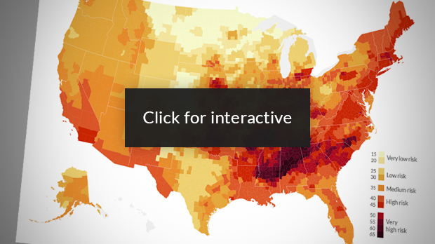
Natural disasters: The riskiest spots in the U.S.
What are the chances your home will get damaged by a tornado, hurricane, earthquake or fire? RealtyTrac crunched the data in more than 3,000 counties nationwide to find out.
I think this map is cool.
Be better if I could 'share' the image here, instead of simply copy/paste the URL - oh well.
It's funny: my immediate family lives in a medium risk zone, but my extended family (surviving Grandma, four aunts, one uncle, several cousins, and many nieces/nephews live in low -risk areas.
Not complaining, just checking out 'natural disaster risk'.
Never seen a tornado, never felt an earthquake, drove by/past a huge wildfire AFTER it'd been mostly contained, never lived through a blizzard (parents have), never listened to a howling sand-storm, never been struck by lightning, never had house and home flooded - rivers/lakes, torrential rains, hurricane - no tsunamis nearby, ....
maybe if I lived near a high-risk area, I would have had experienced something supernatural.
Wait ... Do I really want to have EVERYTHING I physically own destroyed in some kind of unstoppable, unpredictable event NOT MADE/CAUSED by man?
No, not really.
Don't even know if there is a support group for those who survive. (Insurance to rebuild/replace does NOT count)
.. EDIT ...
Found a way to share the image!

What are the chances your home will get damaged by a tornado, hurricane, earthquake or fire? Click on the map above to find out.
http://money.cnn.com/2014/06/19/pf/insurance/natural-disaster-risk/index.html - the news article following
Or maybe it's the colors ... and the statistics ... or the fact it's the country of my birth and youth being depicted?
http://money.cnn.com/interactive/pf/real-estate/natural-disaster-risk-map/index.html?iid=SF_PF_Lead
Natural disasters: The riskiest spots in the U.S.
What are the chances your home will get damaged by a tornado, hurricane, earthquake or fire? RealtyTrac crunched the data in more than 3,000 counties nationwide to find out.
I think this map is cool.
Be better if I could 'share' the image here, instead of simply copy/paste the URL - oh well.
It's funny: my immediate family lives in a medium risk zone, but my extended family (surviving Grandma, four aunts, one uncle, several cousins, and many nieces/nephews live in low -risk areas.
Not complaining, just checking out 'natural disaster risk'.
Never seen a tornado, never felt an earthquake, drove by/past a huge wildfire AFTER it'd been mostly contained, never lived through a blizzard (parents have), never listened to a howling sand-storm, never been struck by lightning, never had house and home flooded - rivers/lakes, torrential rains, hurricane - no tsunamis nearby, ....
maybe if I lived near a high-risk area, I would have had experienced something supernatural.
Wait ... Do I really want to have EVERYTHING I physically own destroyed in some kind of unstoppable, unpredictable event NOT MADE/CAUSED by man?
No, not really.
Don't even know if there is a support group for those who survive. (Insurance to rebuild/replace does NOT count)
.. EDIT ...
Found a way to share the image!

What are the chances your home will get damaged by a tornado, hurricane, earthquake or fire? Click on the map above to find out.
http://money.cnn.com/2014/06/19/pf/insurance/natural-disaster-risk/index.html - the news article following