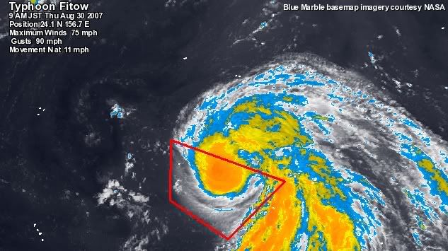
Typhoon Fitow forms
In the West Pacific (near Japan for the Americans that are unaware of anywhere outside of North America, let alone Ohio). Tropical Storm Fitow has crossed the threshold and has been elevated to Typhoon status. This storm is expected to become a powerful Category 4 Typhoon in the next week. It is too early to say whether this Typhoon may become a Super Typhoon since this year's intensity forecasts have been a little bit erroneous in this part of the world this year. I do believe this storm will be a very powerful Typhoon by the satellite representation that has been observed through the day.
For example, in the picture below, in the red trapezoid that I have outlined in red, the feathery white clouds are the cirrus blow off or debris clouds from the deep thunderstorms near the center of the storm. The more feathery and speedier exit (the "debris" clouds move in a clockwise motion above the low pressure center which rotates counterclockwise in the northern hemisphere), the more rapid there are thunderstorms forming. The more rapid the storms develop, the tighter the circulation. The tighter the circulation, the pressure will drop, and then the winds increase.

For example, in the picture below, in the red trapezoid that I have outlined in red, the feathery white clouds are the cirrus blow off or debris clouds from the deep thunderstorms near the center of the storm. The more feathery and speedier exit (the "debris" clouds move in a clockwise motion above the low pressure center which rotates counterclockwise in the northern hemisphere), the more rapid there are thunderstorms forming. The more rapid the storms develop, the tighter the circulation. The tighter the circulation, the pressure will drop, and then the winds increase.
