Geology Field Trip Report - Garibaldi Provincial park
Geology Field Trip Report
Last week, me and the boyfriend went backpacking in Garibaldi Provincial Park, a few hours north of Vancouver, B.C. I love this place, not just because it's beautiful, but because it illustrates the intersection of two of my favorite geological processes: volcanism and glaciation. You know where else there's volcanoes and glaciers? Mars. And a lot of Mars may look like this area.
To start: way, way back when, in the Triassic (200 million years ago. Dinosaurs were just starting to show up.) there was an island arc, much like the Aleutians or the Leeward Caribbean islands. This got smushed into the continent, and then, in the Jurassic (150 million years ago. Full of dinosaurs) magma pushed up from deep in the earth--not breaking the surface--and crystallized into a granite batholith, which eventually became exposed to the air. Eventually, thanks to plate subduction, volcanoes erupted and created the Garibaldi Volcanic Field.
To get to the trailhead, you pass through this zone the government as designated as a landslide hazard. They don't allow any building, and recommend you don't stop your car there for long. This is because just upstream of the aptly named Rubble Creek, is...The Barrier. It's very dramatically named, and it is pretty dramatic looking. Certainly its origin is exciting.
About 9,000 years ago (after the ice ages, after humans crossed the land bridge) lava poured out of Clinker Peak on the the side of Mount Price. (For a great aerial view of the lava flows, go here. There's also nice little documentary about The Barrier.) This eventually hit a glacier, which caused the lava to pool and cool into a 300 meter high cliff. It didn't cool into a solid rock, but rather a deeply fractured one. It is constantly crumbling. Even while we were there, we heard and saw signs of landslides. Here's a big plume of dust. The picture also shows the campground, on the lakeshore beside those long, thin islands.

In the pictures on that link, you can see how the cliffs are gradually eroding farther and farther back. Theoretically, it may someday reach Garibaldi Lake, at which point, life will suck for everything downstream, all the way to Squamish, a biggish town down on Howe Sound.
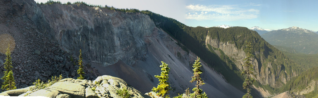
Here's a view of the lava flow from Panorama Ridge, as well as one I marked up. The lava flow is in red, the site of the old glacier in blue, and the resulting Barrier in yellow.


Once you hike up The Barrier, the trail levels off a bit, and you pass two smaller lakes which ponded on the lava dam. The first of these, Barrier Lake, doesn't appear to have an outflow stream. Turns out, the water is soaking into the ground and flowing out through springs in The Barrier--adding to The Barrier's instability.
Soon, you reach Garibaldi Lake itself. The lake is an amazing shade of turquoise thanks to the sediment, known as glacial flour. (This is why bottled water labeled as "glacial" is kind of hilarious. Mmm...silty.) Glaciers can grind stone so fine, it's like flour. This makes the water almost opaque, which adds to the otherworldly beauty. (This shot shows the campground and accompanying "battleship islands")

Here's a glacial phenomenon illustrated very clearly from the campground: hanging valleys. First, a glacier comes along and carves a deep valley. Then, smaller glaciers join it from side valleys. When the glaciers retreat, the result are these smooth valleys that end very high up the main valley wall. In some places, streams flow down these and terminate in spectacular waterfalls. A lot of the waterfalls in Yosemite are examples.

If you climb up from Garabaldi Lake, you reach a plateau covered in alpine and subalpine meadows. From here, you can see the Black Tusk, but to get the best view, head up the trail to Panorama Ridge.

The Black Tusk is sacred to the local First Nations people, who told stories of the Thunderbird who lived there. It's a volcanic neck, the hard core of an ancient volcano which has since eroded away. Give Mount Rainier long enough, and it will probably look something like this. In the Black Tusk's case, its volcano was formed a little over a million years ago. There was a little activity 170,000 years ago, pushing up the lava dome on its side. You can walk up to the base, and even climb it if you've got the gear and know-how. Here's a shot of some people at the base, to give you a sense of scale.

We did not walk up to it, however, we hiked up Panorama Ridge, where there were lots and lots of interesting rocks. I'm honestly not sure what exactly the geology of the ridge is, but it's probably part of a subglacial volcano complex along with the rest of Garabaldi. That is, at least part of it erupted underneath a glacier. There was a lot of pale, rhyolitic lava on it, much of which had been fractured at some point. Superheated water, carrying dissolved quartz, poured in and deposited thick veins of quartz.


You'll notice this quartz is rusty, which is often a sign there's gold nearby, and indeed, there are a few gold mines around here.
Here's another rock. I'm terrible at minerology, but this looks like rhyolitic lava against some kind of sedimentary conglomerate. Given the history of the area, I'd say the sediment is glacial, and this is where the lava flowed over or maybe under it. The bigger rocks in the conglomerate are granite, which I know was around from the Jurassic period. It makes sense that the glaciers would have ground it up. If I'd thought about it at the time, I would have checked the boundary for signs of contact metamorphism, where rock is basically baked when lava touches it. I was too busy avoiding dehydration at the time.

That rock might have been the result of lava over glacial stone. Here's a volcanic stone which has been scraped over by a glacier. The rock was big, smooth and shaped like a whale. When a glacier goes over rock, the tiny rocks embedded underneath the glacier get dragged across the ground rocks like sand paper. They scrape tiny, parallel gouges into the stone.

Speaking of glaciers, here's a shot of the Sphinx Glacier, where two lobes have merged together. A glacier will grind away rock at the sides of its valley, forming a pile of stone called a lateral moraine which is gradually carried along as the glacier moves. When glaciers merge like this, the lateral moraines become a medial moraine.

Here's my favorite landform in the area, The Table. It's a tuya, which is formed when lava erupts beneath ice, and manages to melt a hole which it then flows up into. The result is this steep-sided, flat-topped mountain.

There was a cinder cone to the north of Panorama Ridge, and a hummocky field that looked interesting, but we didn't really have the time or energy to explore it. The Panorama trail was hard, but you do get up close and personal with a lot of rocks.
So that's Garibaldi Provincial Park. I might do another one on Whistler and Blackcomb.
Last week, me and the boyfriend went backpacking in Garibaldi Provincial Park, a few hours north of Vancouver, B.C. I love this place, not just because it's beautiful, but because it illustrates the intersection of two of my favorite geological processes: volcanism and glaciation. You know where else there's volcanoes and glaciers? Mars. And a lot of Mars may look like this area.
To start: way, way back when, in the Triassic (200 million years ago. Dinosaurs were just starting to show up.) there was an island arc, much like the Aleutians or the Leeward Caribbean islands. This got smushed into the continent, and then, in the Jurassic (150 million years ago. Full of dinosaurs) magma pushed up from deep in the earth--not breaking the surface--and crystallized into a granite batholith, which eventually became exposed to the air. Eventually, thanks to plate subduction, volcanoes erupted and created the Garibaldi Volcanic Field.
To get to the trailhead, you pass through this zone the government as designated as a landslide hazard. They don't allow any building, and recommend you don't stop your car there for long. This is because just upstream of the aptly named Rubble Creek, is...The Barrier. It's very dramatically named, and it is pretty dramatic looking. Certainly its origin is exciting.
About 9,000 years ago (after the ice ages, after humans crossed the land bridge) lava poured out of Clinker Peak on the the side of Mount Price. (For a great aerial view of the lava flows, go here. There's also nice little documentary about The Barrier.) This eventually hit a glacier, which caused the lava to pool and cool into a 300 meter high cliff. It didn't cool into a solid rock, but rather a deeply fractured one. It is constantly crumbling. Even while we were there, we heard and saw signs of landslides. Here's a big plume of dust. The picture also shows the campground, on the lakeshore beside those long, thin islands.
In the pictures on that link, you can see how the cliffs are gradually eroding farther and farther back. Theoretically, it may someday reach Garibaldi Lake, at which point, life will suck for everything downstream, all the way to Squamish, a biggish town down on Howe Sound.
Here's a view of the lava flow from Panorama Ridge, as well as one I marked up. The lava flow is in red, the site of the old glacier in blue, and the resulting Barrier in yellow.
Once you hike up The Barrier, the trail levels off a bit, and you pass two smaller lakes which ponded on the lava dam. The first of these, Barrier Lake, doesn't appear to have an outflow stream. Turns out, the water is soaking into the ground and flowing out through springs in The Barrier--adding to The Barrier's instability.
Soon, you reach Garibaldi Lake itself. The lake is an amazing shade of turquoise thanks to the sediment, known as glacial flour. (This is why bottled water labeled as "glacial" is kind of hilarious. Mmm...silty.) Glaciers can grind stone so fine, it's like flour. This makes the water almost opaque, which adds to the otherworldly beauty. (This shot shows the campground and accompanying "battleship islands")
Here's a glacial phenomenon illustrated very clearly from the campground: hanging valleys. First, a glacier comes along and carves a deep valley. Then, smaller glaciers join it from side valleys. When the glaciers retreat, the result are these smooth valleys that end very high up the main valley wall. In some places, streams flow down these and terminate in spectacular waterfalls. A lot of the waterfalls in Yosemite are examples.
If you climb up from Garabaldi Lake, you reach a plateau covered in alpine and subalpine meadows. From here, you can see the Black Tusk, but to get the best view, head up the trail to Panorama Ridge.
The Black Tusk is sacred to the local First Nations people, who told stories of the Thunderbird who lived there. It's a volcanic neck, the hard core of an ancient volcano which has since eroded away. Give Mount Rainier long enough, and it will probably look something like this. In the Black Tusk's case, its volcano was formed a little over a million years ago. There was a little activity 170,000 years ago, pushing up the lava dome on its side. You can walk up to the base, and even climb it if you've got the gear and know-how. Here's a shot of some people at the base, to give you a sense of scale.
We did not walk up to it, however, we hiked up Panorama Ridge, where there were lots and lots of interesting rocks. I'm honestly not sure what exactly the geology of the ridge is, but it's probably part of a subglacial volcano complex along with the rest of Garabaldi. That is, at least part of it erupted underneath a glacier. There was a lot of pale, rhyolitic lava on it, much of which had been fractured at some point. Superheated water, carrying dissolved quartz, poured in and deposited thick veins of quartz.
You'll notice this quartz is rusty, which is often a sign there's gold nearby, and indeed, there are a few gold mines around here.
Here's another rock. I'm terrible at minerology, but this looks like rhyolitic lava against some kind of sedimentary conglomerate. Given the history of the area, I'd say the sediment is glacial, and this is where the lava flowed over or maybe under it. The bigger rocks in the conglomerate are granite, which I know was around from the Jurassic period. It makes sense that the glaciers would have ground it up. If I'd thought about it at the time, I would have checked the boundary for signs of contact metamorphism, where rock is basically baked when lava touches it. I was too busy avoiding dehydration at the time.
That rock might have been the result of lava over glacial stone. Here's a volcanic stone which has been scraped over by a glacier. The rock was big, smooth and shaped like a whale. When a glacier goes over rock, the tiny rocks embedded underneath the glacier get dragged across the ground rocks like sand paper. They scrape tiny, parallel gouges into the stone.
Speaking of glaciers, here's a shot of the Sphinx Glacier, where two lobes have merged together. A glacier will grind away rock at the sides of its valley, forming a pile of stone called a lateral moraine which is gradually carried along as the glacier moves. When glaciers merge like this, the lateral moraines become a medial moraine.
Here's my favorite landform in the area, The Table. It's a tuya, which is formed when lava erupts beneath ice, and manages to melt a hole which it then flows up into. The result is this steep-sided, flat-topped mountain.
There was a cinder cone to the north of Panorama Ridge, and a hummocky field that looked interesting, but we didn't really have the time or energy to explore it. The Panorama trail was hard, but you do get up close and personal with a lot of rocks.
So that's Garibaldi Provincial Park. I might do another one on Whistler and Blackcomb.